![]()
Dushanbe
The relaxed capital
It is only a 3 km ride from the airport to the hostel. At 5:30 in the morning it is already 26 °C warm. We are almost alone on the broad 6-lane road.
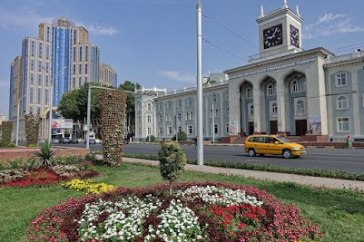
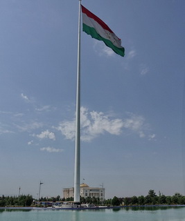
After breakfast we go for a walk in Dushanbe, the capital of Tajikistan. The Rudaki-Prospekt has been designed by a Russian architect. It is lined with representative buildings like the palace of the president, the opera and museums. The 130 m high flagpole is a questionable landmark. The middle of the Rudaki-Prospekt is reserved for pedestrians. It’s a green oasis with maple trees, flowers, sculptures and benches.
In general, Dschanbe is green and pedestrian friendly city with many parks, trees and fountains. It is also a quiet place. Electric Trolleybuses, Marschrutkas1) and Taxis make up most of the traffic. There is not much honking. During the day it gets hotter and hotter. According to weather forecast it is 38 °C.
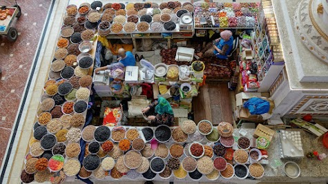
The Mekhrgon Basar lies north-east of the city center. Most food and fashion stalls are inside air-conditioned halls. The nearby victory park overlooks the capital. The park itself is not at all interesting. Our first impression of the Tajiks is very positive, they are friendly and open but not at all intrusive.
1: Marschrutka = A shared taxi or routed taxicab. Backbone of public transportation in many ex-soviet states.
 Sunset on the flight to Tajikistan.
 University of Art and Design in Dushanbe.
 Flagpole and palace of the president.
 Mekhrgon Basar in Dushanbe.
 Piles of melons.
 Dry fruits and nuts.
 The three vendors have the same offering.
 This woman is a "raisin picker".
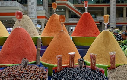 Lovingly arranged spices.
![]()
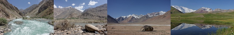
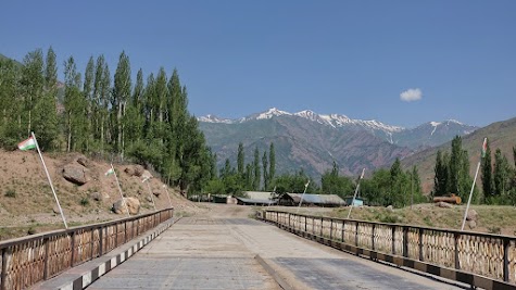
Dushanbe - near Ob-I-Garm, 88 km, 1190 ⇑m
The heat is on, on the street
On the first kilometers the M41 is a 6-lane highway. Luckily it is not very busy. Nevertheless it is quite noisy. On the right lane Marschrutkas and cars stop frequently, which requires a high level of attention. The Opel Astra is the most popular car. Ladas are a rare sight. All cars are packed to the limit – and some even beyond it. Here aluminum profiles are piling up on the roof, there a trunk full of potatoes is challenging the suspension. Trucks are a rare sight.
Between Vahdat and Fayzobod farmland is dominating the scenery. The traffic subsides with every kilometer. Along the road watermelons, cherries, peaches, potatoes, onions and many more is on offer. We see a harvester ready for the museum. Again it is very hot, in the sun at least 40 °C. Kids from the age of about 8 or 9 work in the small shops or stalls along the road. The women wear long, colorful dresses and a headscarf.
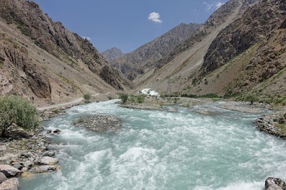
After Fayzabad the ascent to the first pass begins – actually the whole day is one long uphill. The valley narrows. The climb is moderate and the road still good paved. It is lined with many small shops, called "magazins", which we use frequently to refill our water bottles.
Near the pass we try some small paths directing towards the river. The first attempts end in fields or gardens were people are still working. In the end we pitch our tent on a dry meadow overlooking the valley, some dozen meters above the river. Four brothers with a herd of cows climb up the hill. One of them speaks some English. Unfortunately our Russian skills are just enough to survive.
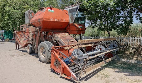 Harvester ready for the museum.
 Fruit trees near Fayzobod.
 Between Fayzobod and Ob-I-Garm.
 Four brothers with a herd of cows climb up a hill.
![]()
Ob-I-Garm - Nurobod, 76 km, 1135 ⇑m
A valley drowns
In the morning at 6 it is already warm and sunny. We start without breakfast. The first kilometers are downhill. Soon we reach the spa-town of Ob-I-Garm. We didn't really get the charm of this place. But we didn't notice any shop or tea-house either. It seems, we rode through it too fast. The road is quite steep. We are not keen climbing it up again.
The Pamir-Highway winds its way through a beautiful, narrow, rocky canyon. Donkeys graze at the edge of the road. We reach the Vaksh valley. The Vakhsh river has swollen to a lake. A few kilometer away the 340 m high Roghun-dam is build. It will be the highest dam in the world. It’s sad and hard to imagine, that the valley and the villages we will ride through today, are going to drown in a giant lake. 😢
The old road, that follows the Vakhsh river, has obviously been given up. We try to follow it anyway. We cross a shallow river, climb over some land-slides. But at some point it's just getting to risky and we turn around. After one hour we are back at the M41. Meanwhile it is pretty hot and we still had no breakfast. Not ideal for climbing a steep hill on gravel road. A friendly Tajik rescues us by giving us a bread and 2 tomatoes. At the pass the driver of two Kamaz trucks are cooling their engines with water. On the foot of the pass we rest for 1.5 hours in the garden of a tea-house next to a small river.
For the rest of the day the road is paved. We have to climb a second pass before we reach the Vakhsh valley again. It is amazingly beautiful. Several times the river forms a deep canyon and exposes reddish and sand-colored rock formations. In the narrow valley trees, gardens and willows add some green to the scenery. Every few kilometers a blue painted wooden toilet house and water fountains next to the road offer a great service for travelers like us. The fountains are simple pumps providing water from a nearby river.
This evening we pitch our tent next to the Vakhsh river, near a narrow suspension bridge. Wood is scarce. Two elderly woman collect the pieces washed ashore. They fill several bags roughly a meter high. Later in the evening a man with a small truck picks them up.
 Donkey graz in a narrow canyon.
 Kamaz truck at a pass.
 View over the Vakhsh valley.
 Wooden toilet house at the Pamir-Highway.
 Donkey in Vakhsh valley.
 Tajiks bathe in a tributary of the Vakhsh.
 The Vakhsh has high tide.
 Cows next to the Pamir-Highway.
 Bride over Vakhsh.
 The Vakhsh has a strong current.
![]()
Nurobod - Tavildara, 77 km, 1265 ⇑m
The mobile shop
Again we start early in the relatively cool morning. The scenery changes every few kilometers. Here the road and the river squeeze through a narrow canyon. There the valley opens and gives the river ample room to meander, divide into several arms or widen to small lakes. Also the mountains vary. Sometimes the naked rock is visible and presents layers in many colors including grey, red and copper green. Another time the steep slopes are covered with grass, bushes and small trees. Also the surface of the road changes constantly. During the day it shows the whole range from good asphalt to rough gravel and soft sand.
At the entrance of the Khingob valley, a police post checks our passports. The small villages have no shop or tea house. In one of the small places the villagers gather around a truck. We inquire for a shop. Everyone grins. The truck is the shop. It offers a broad range of vegetables, as well as flour, rice and noodles. But also things like cement or nails. We ask for 4 tomatoes, 4 cucumbers and one onion. Everyone laughs. Here they usually sell in kilos. For the few pieces we want, they don’t have a price, so we get them for free. We inquire for bread. Stupid question. Every villager bakes its own bread. But soon a boy brings us a plastic bag full of bread. Far too much. And again, they don’t want any money. So we give the kids as many candies as we can to say thank you. A few kilometer down the valley we find a nice spot for our breakfast. In the shade of two small trees and with a view on a rock formation shaped like a heart.
Pure water runs down the mountains. We fill it directly into our water bottles. In Kaftarguzar we spend 2 hours in a tea house at the "Blue Lake". In the shade of trees and in the refreshing water we forget the heat for a while.
Today many short "waves" and the often rough road eat up our energy. In the villages the kids welcome us with a loud "Hello". As often as possible we stop and give them sweets. Although we have 300 g with us, it is hard to please them all.
Donkeys, goats and cows wander around. Some chill in the bright sun, in the middle of the road. In the afternoon, it gets about 40 °C hot. We frequently rest in the shade. One option are the big bus stops, which are fenced in to keep the animals out.
In Tavildara we take a homestay. Rooms and bath are rather simple. On the other hand it costs only 15 Euro including dinner and breakfast - for the two of us. Jörg is struggling heavily with the heat. I have just (the usual) digestion issues.
 Entrance to Khingob valley.
 The Khingob river carved out a beautiful valley.
 Lunch in the Khingob valley.
 Rock formation shaped like a heart.
 The "Blue Lake".
 The hilly gravel road is exhausting.
 Piles of hay near Tavildara.
 Rock formation over Tavildara in the evening light.
![]()
Tavildara
Medical intermission
Jörg is not doing well. His body is not able to deal with the great heat. He has no appetite and therefore no energy. So we stay another day. Our homestay is also a bank and a restaurant. The house is surrounded by a garden with many trees. We make ourselves comfortable on yellow plastic chairs at a yellow plastic table and watch people coming and going. The water fountain at the entrance is popular by everyone in the small town. In the afternoon we watch the crossroad. It is equipped with traffic lights, which are entirely useless. The streets are so quiet that it is save for the kids to play on the crossing.
 Garden of the homestay in Tavildara.
![]()
Tavildara - near Saghirdasht Pass1), 47 km, 1300 ⇑m
The first pass
We start early and take it easy. The Khingob river valley is flat, wide and surrounded by grey mountains. After about 10 km the long climb up the Saghirdasht Pass begins. The grade is steady and moderate, the gravel road mostly good to ride. We watch farmers harvesting hay by hand. A young man tells us, traveling his own country is an unreachable dream for him.
In many sections the mountains are amazingly green. Every now and then some spectacular rock formations have to be admired. Next to the road wild rivers rush down the mountains. The last chance to fill up stocks is in Qala-i Husein. Near the small village of Pastirog a landslide covers the road for well over 100 m. We are able to climb over the pile of dry, red mud, but Jeeps are not able to cross this blockage. Less than a kilometer later we have to cross a river about 50 m wide. It’s less than 50 cm deep but has a strong current. After a bad experience in Kyrgyzstan we always carry our panniers separately across.
Now we are almost alone on the street. A donkey or a car per hour is quite acceptable. We still take it easy and crawl up the pass with 5-10 km/h. This gives us ample time to admire the beauty around us. The road winds its way through rich, colorful meadows. Early in the afternoon we pitch our tent next to a creek. The panorama is stunning. Snow capped mountains on one side, colorful meadows on the other. Shepherds with goats wander through the grassland. The first one walks, the second rides a donkey, the third rides a horse. We are camping at an altitude of 2800 m, but in the sun it is still 30 °C warm. So washing in the cold creek is no issue.
1: aka Khoburobot Pass.
 Southern end of the Saghirdasht pass.
 The climb is steady and moderate.
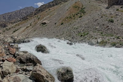
 Wild mountain river.
 Rock formation at 2000 m - it's 34°C.
 Ascent to Saghirdasht pass.
 Creek runs through a meadow.
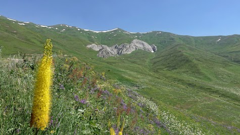 Colorful mountain grassland.
 Shepherd on its donkey.
 Jörg on a shepherds horse.
![]()
Saghirdasht Pass - near Qala-i-Khumb, 62 km, 675 ⇑m
Three landscapes in one day
The day begins with a ride through alpine grassland with small snowfields here and there. Shepherds with herds of goats roam the mountains. All around, in some distance, snow caped summits. At the 3252 m high Saghirdasht pass a sign warns of mines.
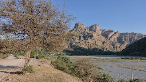
The rest of the morning is downhill. 1800 vertical meters! The road winds its way through spectacular valleys and canyons. As yesterday, even steep slopes are amazingly green, dotted with rock formations in the colors grey and red. Creeks rush down nearly vertical hillsides and merge to a whitewater river. Wow! The gravel road is mostly good to ride. We meet a bee-keeper harvesting honey. After the steep serpentine section, a police post checks our passports. In the following section the Khumb river is especially wild and loud. That’s really white water. About 5 km before the Panj valley, a hotel at the river offers an excellent lunch.
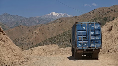
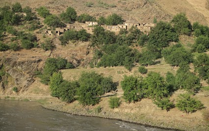
We reach Qala-i-Khumb after 14 o'clock. But still most shops have closed for lunch. The river Panj marks the border between Tajikistan and Afghanistan. The mountains on both shores are high, rocky and glow reddish in the sunlight. The villages appear like green oasis in this harsh landscape. Irrigation and terracing allows a modest farming. Obviously every field and every garden is the result of hard work. This land cannot feed herds of cows or goats. On the other hand we notice chicken in the villages. We are back on the main road. The amount of cars is still no issue. The heavy trucks bother us more.
Most of the time, the space between the Panj and almost vertical mountains is just enough for a narrow gravel road - called Pamir Highway. But every few kilometers sandbanks offer the opportunity for camping. So we pitch our tent just 3 m from the Panj and less than hundred meters form the Afghan shore. Our first impression, the villages on both sides of the river are not so different. Indeed people on either side of the Panj consider themselves as Pamiris. A closer look reveals, houses and streets in Afghanistan are poorer.
 Beautiful northern descent of the Saghirdasht pass.
 Road winds through a narrow gorge.
 The mountain slopes are amazingly green.
 Traffic is not an issue.
 Begin of the serpentine section.
 Descent of the Saghirdasht pass - 1800 m downhill.
 The Khumb river rushes through rapides.
 The rapids are amazingly loud.
 Panj valley near Qala-i-Khumb.
 Gas station - notice the solar panel.
 Village in Afghanistan.
![]()