![]()
Sary Tash - Pik Lenin, 60 km, 665 ⇑m
"Detour" to Pik Lenin
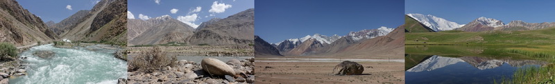
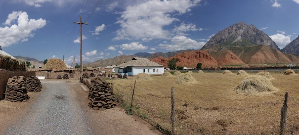
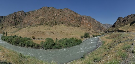
We follow the Alay valley westward. The Trans-Alay Range (left hand side) dominates the scenery. The heavily glaciated mountains reach heights over 7000 m. The Alay Range (right hand side) appears like green, rolling hills, but still reaches altitudes beyond 4500 m. The green valley is several kilometer wide. Goats, cows, horses and yaks graze on lush meadows. Beehives stand around fields of light red blooming flowers. The road is well paved, tailwind is pushing, the 30 km to Sary Mogul are a piece of cake.
In Sary Mogul we take the dirt road heading to Pik Lenin1). A bridge crosses the Kysylsuu river. The road is no big challenge. Most of the time the climb is moderate. The grassland is dotted with rolling hills, most of them only a couple of meters high. It started getting hazy, in the Trans-Alay, already in the morning. In the afternoon the mountains are more and more covered by thin clouds.
We stay in a Yurt-Camp between rolling hills and small lakes. The 7134 m Pik Lenin is just 18 km way, but covered in clouds most of the afternoon. In the valley below, thick, grey clouds pile up, a thunderstorm comes up.
1: From Russian Пик Ленина = Pik Lenina.
 Beehives stand around fields of light red blooming flowers.
 Path to toilet in Sary Mogul.
 Donkey carries drinking water in Sary Mogul.
 Dirt road to Pik Lenin.
 Sleeping cows in our Yurt-camp.
 Sleeping calv.
![]()
Pik Lenin - Sary Tash, 60 km, 335 ⇑m
A magical moment
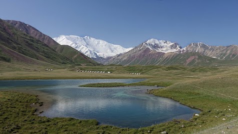
Early in the morning we enjoy the reflection of Pik Lenin in one of the small lakes. It’s a magical moment and it last only half an hour. When wind comes up the reflections are passé.
The way back to Sary Tash is the same we came yesterday. On the main-road we notice trucks filled with coal. Big and small, old and new, it seems every vehicle is used. Getting Kyrgyz money is by far not as easy as we expected. Sary Tash has no Bank and the ATM is out of order. Shop keepers and homestay hosts are not interested in Tajik money, not even in US dollar. The solution for the problem are cyclists heading to Tajikistan. The shop is well stocked. But the shop keeper ignores us persistently. He prefers talking with his friends.
 The 7134 m high Pik Lenin early in the morning.
 Reflections of Pik Lenin in a small lake.
 Pik Lenin is about 18 km away.
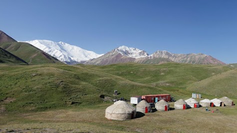 View over "our" yurk camp on Pik Lenin.
 Rolling hills and small lakes surround the Yurt-Camps.
 Goodbye, Pik Lenin.
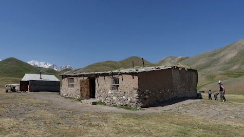 Small farm not far from the Yurt-Camps.
 Milk is pasteurized.
 A last glimpse on Pik Lenin.
![]()
Sary Tash - Gulcha valley, 80 km, 705 ⇑m
More than a bed
The day begins with a rather unspectacular climb up a 3615 m high pass. The rest of the day is downhill. The scenery changes continuously. First the hills are covered only with meadows and some rocks. Step by step bushes and conifers populate the landscape. Although the meadows are lush we see no animals. This grass is turned into hay and stored on the flat roofs. The valley is becoming more and more fertile. The distance between the villages is getting shorter. We notice big deciduous trees. For a while reddish rock formations make the valley very appealing. Nomads live in yurts along the river.
The valley is scenic but camping spots are rare. Mostly because the villages are too close to each other. So we once again end up in a yurt-camp. It’s small, has only one yurt for guest. The family lifs in a UNHCR-tent and a container. Our hosts have 5 kids. Two girls not older than ten, two toddler and a teenage boy. The girls are curious and full of energy. We show them our equipment and play volleyball together. Later even the mother and grandmother take part the volleyball game. So we have quite some fun. The men come home after sunset, after a long day of harvesting hay.
 Gulcha valley.
 Reddish rock formation in the Gulcha valley.
 The river Gulcha has a vast river-bed.
 The Gulcha valley is scenic.
 These mountains are "only" 4000 m high.
 In Kichi-Karakol the hay piles up on roofs and on fields.
 Yurt and fish ponds, something we haven't seen before.
 Cows pass a particularly colorful rock formation.
 Cattle transport in the Kyrgyz way.
 The Gulcha valley narrows.
 Path to the toilet in our Yurt-camp.
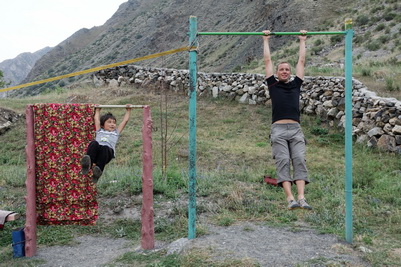 The daughters of our hosts keep us busy.
 Pull ups, volleyball, the girls are full of energy.
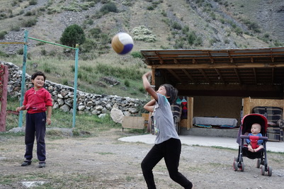 We have quite some fun.
![]()
Gulcha valley - near Ylai-Talaa, 82 km, 965 ⇑m
Hay harvest and breakdown assistance
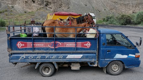
The Gulcha valley turns into a narrow canyon with rocks in grey and reddish colors. Till we reach the town of Gulcha the mountains turn into low rolling hills. The landscape is dryer than yesterday. We are 2 days ahead of our schedule. Spontaneously we decide for a detour. We leave the M41 and turn on the back-road to Uzgun. The first 15 km are not very appealing. Just many villages surrounded by green rolling hills. It takes us a while to discover the beauty of this landscape. A family is washing a carpet on the street. On the grasslands the hay is piled up to heaps, up to one meter high. On meadows not mowed yet, the grass is knee high with many flowers and herbs. Whole families with brush-cutters are harvesting the grass – and some of the meadows are huge. The hay is transported to the villages with all available vehicles. Trucks, pick-up trucks (mostly Hyundai Porter), even horses pulling the hay on simple wooden frames. All vehicles are packed to the absolute limit. Trucks need the full width of the road.
The highest point is reached at an altitude of just 2400 m. Two horses are towing a VW Golf over the pass. What a picture! So far the gravel road was good to ride. The downhill on the other side is quite rough. We ride through another wide valley dominated by green rolling hills. We are looking for a camping spot next to the river. But it takes us quite a while to find one not already occupied by cows or horses. In the evening we watch flocks of birds. After sunset grilling chirp.
 We continue our way through Gulcha valley.
 The Gulcha valley stays scenic.
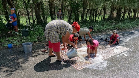 A family is washing a carpet on the street.
 Truck packed to the limit with hay.
 Hay is piled up to heaps, up to one meter high.
 Two horses are towing a VW Golf over the pass.
 After the job is done, the rider show off a bit.
 Green rolling hills on the way to Uzgen.
 On many fields hay is harvested.
 Horse is pulling the hay on two-wheeled trailer.
![]()
Ylai-Talaa - Osch, 118 km, 680 ⇑m
The last miles are a flop
The valley widens and we see more and more farmland. Grain and corn are grown. The scenery of rolling hills, dry gras, popular avenues and a river reminds us to southern Europe.
Meanwhile farmland dominates the landscape. The traffic increases. We turn on a quiet dirt-road. On our Garmin it looks fine. It starts as bumpy path. One flooding follows the next. In the end it is more a creek than a path. Swarms of red dragon-flies intensify this impression. But we make it and even enjoy our little adventure. The soil is very fertile and dark. The (paved) road meanwhile is framed by reed, up to 2.5 m tall.
So far our detour was ok. Uzgun is a big disappointment. The ancient minaret and mausoleum is not at all worth a detour! The city with 50.000 residents has not even a hotel or hostel. The highway to Osch is also a flop. It’s very busy, noisy and smelly. Many heavy trucks. The fertile farmland of the Fergana valley is not a good distraction. The good news, it’s only 55 km to Osch and it’s an easy ride. The hotel half-way is not really an option. The chaotic traffic in Osch increases the stress level one more time. A hot shower, a cold beer in a cozy homestay and we can smile about this short episode on a long trip.
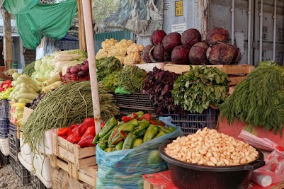
The most interesting place in Osch is the bazaar. We enjoyed it. It’s huge, colorful, angled, crowed and has many faces. All kinds of food of course. But also fashion, household articles, all kind a metal or electrical spare parts. We even find two bicycle vendors. Well, bicycle boxes were not on offer. But we get several meters foil, which will make a great job protecting our bikes on the flight. The Suleiman mountain for sure provides the best view over Osch. The "National Historical and Archaeological Museum" is not exactly a must see.
 The most interesting place in Osch is the bazaar.
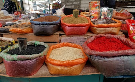 Spices are on offer.
 The potato vendor plays with the smartphone.
 Do you need some garlic?
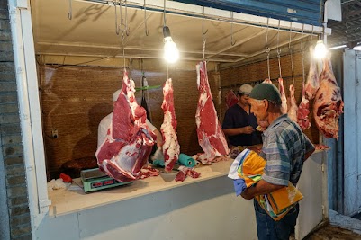 Our do you prefer meat?
 The cookys aren't bad either.
 The vendor of dried fruits has a winning smile.
 But maybe you prefer fresh fruits?
 Of course also fresh bread is on offer.
![]()
Summary
In 4 weeks we cycled 1.750 km and 21.000 vertical meters. We endured 43 °C heat in the Panj valley and -1 °C during the night at an altitude of 4300 m. Some gravel road challenged us but most roads were better than expected. Altitudes over 4000 m are challenging, luckily we coped well with it. Greasy food troubled by digestion for 2 weeks. But the landscapes are just mind-blowing. The people are honest, friendly and adorable. We just can recommend it.
![]()